About Course
 Unlock the power of AutoCAD in layout design with this hands-on course tailored for urban planners, surveyors, GIS professionals, and designers involved in master planning and land subdivision.
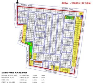
“Master AutoCAD Land Parcellation” guides you step-by-step through the process of creating accurate, automated land parcel layouts using industry-standard techniques. You’ll learn how to efficiently generate and label land parcels, automatically calculate parcel areas, and apply sequential polygon numbering — all within the AutoCAD environment.
Whether you’re working on masterplans, urban layouts, or cadastral mapping, this course equips you with practical skills to boost productivity, eliminate repetitive tasks, and deliver error-free parcel designs.
Course Content
Mastering Autocad Land Parcellation Concepts
-
Module1 – Master Autocad Land Parcellation – Polygon Subdivision
00:00 -
Module 1 Quiz (Master Autocad Land Parcellation Subdivision)
-
Module 2 – Master Autocad Land Parcellation – Automatic Labelling.
00:00 -
Module 2 Quiz (Master Autocad Land Parcellation Automatic Labelling.)
Student Ratings & Reviews

No Review Yet